
Suzanne Stewart
Staff Writer
Planetary Science Institute Senior Scientist Hanna Sizemore was the guest speaker at the February 25 Durbin Lions Club meeting, where she talked about the field research she did in the Arctic last year.
Sizemore, who is a native of Pocahontas County, works out of an office at the Green Bank Observatory for PSI, a NASA contractor. Most of her research is related to the space craft that are in orbit around Mars, on the surface of Mars or in orbit around the main asteroid belt.
“Typically, I’m spread between multiple NASA projects, so at any given time – five to seven different things are going on which are funded separately,” she said.
Sizemore explained that she studies ground ice which is exactly what it sounds like – ice in the dirt.
“I’m concerned about places where that dirt never thaws, where it’s always frozen,” she said. “This can occur on Earth, on Mars and on many asteroids on the main belt including the biggest one which is called Ceres.”
Sizemore studies the ground ice that is found under a layer of dry dirt which is easy to sweep or shovel out of the way. Under that dirt is either solid pure clean ice or soil that is cemented together with ice.
“My core training is in predicting where we can find this ice, how deep it is, how far we have to dig down to get to it and how it has gotten to be where it is,” she said. “I cut my teeth on the Phoenix Mars mission, basically predicting how deep the ice was and understanding how the depth would vary by location on the planet.”
For the Phoenix mission, Sizemore helped decide the best place for a rover to land where the ice wasn’t too deep for the robot arm to reach it and there was enough dirt on top that the descent thrusters didn’t blow it all away as it landed.
“We actually managed to thread that needle very precisely,” she said.
There are several reasons why NASA is interested in learning more about ground ice on Mars and the asteroids. For starters, there’s the age-old question about why Earth is inhabitable, and Mars is not. It is known that Mars is cold and frozen, but was it able to support life before it became frozen?
“I would say for the first half of my career that climate and life question was the big motivator for all of this ice research,” Sizemore said. “Over the last ten, or twelve, fifteen years, there is a second motivation and that’s rocket fuel.”
Rocket fuel is very expensive and when a spaceship goes to Mars, it needs to have enough rocket fuel for a round trip, which determines the size of the ship. If the ship could refuel on Mars, it could be sleeker and not as heavy.
“It turns out that you can make rocket fuel with ice,” Sizemore said. “We’re going to set the ship down on a glacier, they’re going to drill, melt it, they’ll have all the water they want for rocket fuel that they can make there.”
That led to Sizemore’s study of Pingos. A pingo is an ice cored hill that forms in permafrost.
“You’ve got an active permafrost layer and an inactive permafrost layer,” she explained. [The active layer] freezes and thaws. [The inactive layer] is always frozen. When the permafrost grows, that ice expands, it pressurizes the water in the aquifer, it tries to get out and injects it into that freezing layer and you get a big dome of ice that pushes these neat little hills up.”
There are pingos in several locations on Earth and there are candidate pingos on Mars and Ceres. Since the ones on the latter two can’t be studied, the ones on Earth are of great importance for researchers such as Sizemore.
“That’s where PingoSTARR comes in,” she said. “This is the Pingo Subterranean Aquifer Recognizance and Reconstruction. We have a real winning acronym.”
PingoSTARR is part of NASA’s PSTAR – Planetary Science and Technology through Analog Research program which solicits research to study exotic terrestrial environments to better understand other planets.
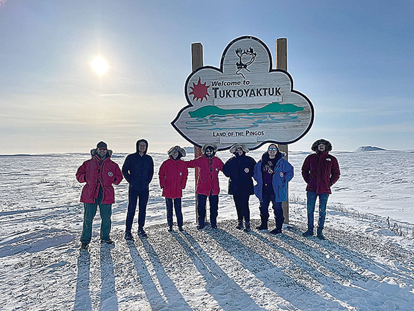
The program received four years of funding and went out into the field three times in the Arctic. Last year, a team of eight, including Sizemore, traveled to Tuktoyaktuk to study pingos in the Pingo National Landmark.
“The hamlet of Tuktoyaktuk is smaller than Marlinton, but bigger than Green Bank,” Sizemore said. “This is one of six communities in the Inuvialuit resettlement region. Tuktoyaktuk literally means resembling a caribou because there’s a rock formation sticking out of the ocean that looks like antlers.
“This location offered several advantages to us – first a quarter of the Earth’s pingos are there and there’s this national landmark that protects several large named pingos from being disturbed,” she added.
While in the hamlet, the scientists stayed with tribal leaders of the Inuvialuit and were always accompanied by one of the locals to ensure the protection of the national landmark.
The scientists stayed with Roger and Winnie Gruben, two very influential tribal leaders.
“It was truly incredible to stay with them,” Sizemore said. “Roger was one of the people who actually helped negotiate the land agreement to get control back from the Canadian government and for the native people to get control of their wildlife and all the land management and clean up environmental damage from the people who had been there.”
Sizemore and the rest of the team were there for 14 days and spent most of their time out in the field, using three geophysical techniques to diagram and map the pingos.
They used Capacitively Couple Resistivity, Ground Penetrating Radar and Time Domain Electromagnetic Method.
Those three techniques took a lot of physical exertion to run the equipment along the top of the pingos and successfully map what was under the snow.
“We had to get the sleds up with pulley systems,” Sizemore said. “It took a three to one pulley to go over the hill. I was light; I was by far the smallest person on this team. I had to hold the tail and keep the tension on the pulley.
“They tried to have me pull weight and all that happened is the sled went down, and I went up,” she added, laughing, “That was really hard, particularly since I was running hard in snowshoes, in the wind, with a lot of resistance and then you’d have a hard time breathing through all your gear.”
Not to mention the temperatures. On a good day, it was minus 20 Celsius. On a bad day, it was minus 43 C.
“We were suited up as if we were on the Moon,” Sizemore said. “Many, many layers. Typically, you didn’t let your face even get exposed. Frostbite was a very serious danger, even after a few minutes. We did have some days where you could take off your mask for a while.”
Those 14-hour days were long and arduous, but they yielded a lot of data that is being compiled and analyzed now.
“We ultimately did get to take complete data sets on nine different pingos spanning most of the national landmark,” Sizemore said. “The big surprise of some of this work is that we knew there would be big hills with a big fall of ice in the middle and we knew there would be scars – a place where a pingo had grown and then the ice melted and drained away and made a hole.
“What we didn’t expect was that there would be some really big pingos – topography still intact – with very little ice left,” she continued. “That’s something we’re still working on to try to understand.”
There were also small pingos, young and pancake-like hills that were just starting to form and instead of having a single source of ice, they had multiple columns of ice starting to come up.
Sizemore said all the data collected at Tuktoyaktuk and in Dead Horse, Alaska, is being processed by the team and herself.
“We’re kind of deep in the process of doing the inversions of all the data, combining the three types of data, trying to make 3D reconstructions of the structure inside and writing a lot of papers,” she said.
In addition to this project, Sizemore is also a student at Cornell University where she is working on a numerical model of the process of the water flowing in and forming pingos.
“Ultimately, we’ll combine all this work about the terrestrial structure, the planetary modeling and we’re going to make recommendations for what we should actually put on rovers on space missions.”
